
New Layers Added to Gray's GIS Maps
Posted on: November 9, 2021 - 11:06am
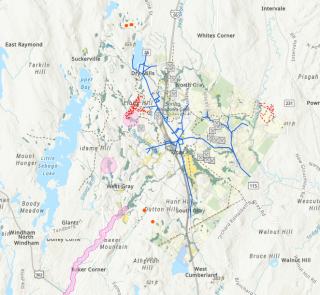
The following layers have been added to our online Geographic Information System maps located here:
- DEP Mining Sites
- Gray Water System
- Gray Trails
- Endangered Threatened and Special Concern Wildlife
- Vernal Pools
- Aquifers
- Deer Wintering Areas
- FEMA Flood Zones
- NWI Wetlands
- USDA Soils Data (categorized by slope)
- Overlay Zones
- Shoreland Zoning
- Zoning Districts
- Contours (2ft)
- Conserved Lands
If you have any questions about GIS maps, please contact the Town of Gray's Tax Assessor at 207-657-3339 ext.112